Are you ready for the grand finale?
Think carefully before you answer! Because today things get dramatic, dirty, and maybe even a little bloody!
The final stage once again challenges the crew with rough terrain and treacherous electronic tricks.
All the rest can be found in the penultimate log entry of the acting Captain.
Captain’s Log
The sixth and final stage of our tour through southern Germany from Wolpertshausen to Ilshofen was only 9 km long, but it turned out to be quite an adventure.
Group 3 got lost at a junction. In other words, no one noticed that there was a junction there at all. The Komoot app does not tell you what to do at every intersection or fork in the road. You would think that you would just keep going straight ahead. But what if it’s half left and half right? Which is closer to straight ahead? Sighted people look at the hiking map on their smartphone and see where the route goes and where they are. If you are blind, you can’t do that. The MyWay and Seeing Assistant Go apps were therefore used to supplement this. You can import the hiking routes as geographical points and see where the next point on the route is. The app then says, for example: Point 43, 50 meters at 3 o’clock. Then you know that you have to turn right. The group followed a path that eventually became unrecognizable. The next point was 50 meters away at 3 o’clock. Should they now go back a long way and look for the right path? That would be a big detour. So they turned right and headed straight through the wedge… it was only 50 meters. But the slope became steeper and slippery. A sighted helper shouted from above: “Turn back! You can’t get up here.” Everyone wanted to try anyway. They crawled up the mountain on their knees and hands. Dirt and stones slid down towards those following behind. Many needed help. But finally, everyone was back on the right path, covered in dirt, scratches, and even blood. One participant said, “This is exactly the adventure I was looking for.” Two others simply said, “We’re glad to have gotten out of there alive.”
The 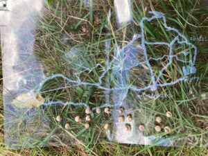 of the day shows the start in Wolpertshausen as a circle in the middle of the left edge. Below it, the Eichelberg is represented by a triangle. The hiking route, marked by a thin line of dots, runs a short distance south and then turns east. It runs fairly straight east to Ilshofen, crossing four roads. All labels are again printed in Braille. The map lies on a meadow. In the upper unprinted third, the word “Nature” is represented in Braille using acorns collected in the forest.
Das letzte Gefecht, auf Händen und Knien
Seid ihr bereit für das große Finale?
Überlegt euch eure Antwort gut! Denn heute wird es dramatisch, dreckig und vielleicht sogar ein bisschen blutig!
Die letzte Etappe fordert die Crew noch einmal mit unwegsamem Gelände und tückischen elektronischen Helfern heraus.
Alles Weitere erfahrt ihr im vorletzten Logbucheintrag des amtierenden Captains.
Logbuch des captains:
Die sechste und letzte Etappe unserer Tur durch Süddeutschland von Wolpertshausen nach Ilshofen war nur 9 km lang, aber sie hatte es ungewollt noch einmal in sich mit großem Abenteuerfaktor.
Gruppe 3 hatte sich an einer Abzweigung verlaufen. d. h. keiner merkte, dass da überhaupt eine Abzweigung war. Die App Komoot sagt nämlich nicht bei jeder Kreuzung oder Abzweigung an, was man tun muss. Man sollte meinen, dann läuft man einfach geradeaus. Aber was ist, wenn es halb links und halb rechts geht? Was ist dann eher als geradeaus anzusehen. Sehende schauen auf die Wanderkarte auf ihrem Smartphone und sehen, wo die Route verläuft und wo sie gerade sind. Wenn man blind ist, geht das nicht. Ergänzend wurden daher die Apps MyWay und Seeing Assistant Go genutzt. Man kann die Wanderrouten als geografische Punkte dort importieren und kann nachschauen, wo der jeweils nächste Punkt auf der Route liegt Die App sagt dann z.B.: Punkt 43 50 Meter auf 3 Uhr. Dann weiß man, dass man genau nach rechts gehen muss. Die Gruppe ist einem Pfad gefolgt, der irgendwann nicht mehr zu erkennen war. Der nächste Punkt lag in 50 Metern auf 3 Uhr. Jetzt ein großes Stück zurück gehen und den richtigen Weg suchen? Das wäre ein großer Umweg. Also nach rechts mitten durch den Wed … sind ja nur 50 Meter. Aber der Hang wurde immer steiler und rutschiger. Ein sehender Helfer rief von oben: “Kehrt um! Hier kommt ihr nicht hoch.” Alle wollten es trotzdem versuchen. Sie krochen auf Knien und Händen den Berg hoch. Dreck und Steine rutschten nach unten den Nachkommenden entgegen. Viele brauchten Hilfe. Aber schließlich Standen alle wieder auf dem richtigen Weg voller Dreck, Kratzern und auch Blut. Eine Teilnehnerin sagte: “Das ist genau das Abenteuer, das ich gesucht habe.” Zwei andere meinten nur: “Wir sind froh, noch mal mit dem Leben davongekommen zu sein.”
Die taktile Karte des Tages Zeigt den Start Wolpertshausen am linken Rand in der Mitte als Kreis. Darunter ist mit einem Dreieck der Eichelberg dargestellt. Die Wanderroute als dünne Linie aus Punkten verläuft ein kleines Stück nach Süden und biegt dann nach Osten ab Sie verläuft recht gerade nach Osten bis nach Ilshofen und kreuzt dabei vier Strassen. Alle Bezeichnungen sind wieder in Braille gedruckt. Die Karte liegt auf einer Wiese Im oberen nicht bedruckten Drittel ist aus Eicheln, die im Wald gesammelt wurden, in Braille das Wort “Nature” dargestellt.
useful links:
Read all articles on: livingbraille.eu
Contact us with your contributions, ideas and questions by: braille200@livingbraille.eu
Social media: Braille 200 on Facebook