A new day – and another stretch of trail lies behind the enduring crew.
Was it easy? Was it tough?
You’ll find out in today’s latest log entry from Captain Reiner Delgado, of course accompanied by the matching photo of the route.
Captain’s log:
The third tour from Buehlertann to Vellberg was only 9 km and was compleetly only on asphalt ways. It was sunny and 26 degrees. This did not promiss to be a big adventure. But the first 50 meters were quite tricky. The groups had to find a certain street close to the starting point. It was not so clear in which dirrection to walk. The street to find didn’t seam as one, but more as a backyard. Finnally the grup found the right way and from there the walking and the navigation was really easy.
“It is like often in life”, one participant said, “the first step is the most difficult. Manage it and then you can go on.”
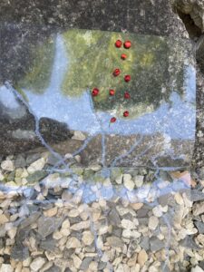
The village Buehlertann is marked with a circle of dots at the bottom in the middle of the map The hiking way as a thin line of dots goes from there to the north and after some kilometers to the west where it raches Obersontheim. It meets several roads represented by large lines of dots and goes to the north to Untersontheim. From there the way goes to the north-west to Vellberg again meeting some bigger roads.
Additionally on the right side of the map there are two mountains represented by triangles: Schlegelsberg in the north and Hammerberg in the middle. All names are writen in braille.
On the left side of the map there are rowanberries. These berries are about 6 mm thick and red. The group found them on the way. They form the word “hike” in braille.
Did you know that the small rowanberries are not poisonous! when you dry or heat them?
Wander-Trek: Voyager, Tag 3
Ein neuer Tag – und ein weiteres Stück Weg liegt hinter der ausdauernden Crew.
War es leicht? War es schwer?
Die Antwort findet ihr auch diesmal im neuesten Logbucheintrag von Captain Reiner Delgado, selbstverständlich zusammen mit dem passenden Foto der Wegstrecke.
Logbuch des Captains:
Die dritte Tour von Buehlertann nach Vellberg war nur 9 km lang und verlief komplett auf asphaltierten Wegen. Es war sonnig und 26 Grad warm. Das versprach kein großes Abenteuer zu werden. Aber die ersten 50 Meter waren ziemlich knifflig. Die Gruppen mussten eine bestimmte Straße in der Nähe des Startpunkts finden. Es war nicht ganz klar, in welche Richtung man laufen musste. Die gesuchte Straße sah nicht wie eine Straße aus, sondern eher wie ein Hinterhof. Schließlich fand die Gruppe den richtigen Weg und von dort aus waren das Wandern und die Navigation wirklich einfach.
„Es ist wie so oft im Leben“, sagte ein Teilnehmer, „der erste Schritt ist der schwierigste. Wenn man ihn geschafft hat, kann man weitergehen.“
Die taktile Karte dieser Tour liegt auf einem steinigen Untergrund. Das Dorf Buehlertann ist mit einem Kreis aus Punkten unten in der Mitte der Karte markiert. Der Wanderweg als dünne Linie aus Punkten verläuft von dort nach Norden und nach einigen Kilometern nach Westen, wo er Obersontheim erreicht. Er kreuzt mehrere Straßen, die durch große Linien aus Punkten dargestellt sind, und führt nach Norden nach Untersontheim. Von dort verläuft der Weg nach Nordwesten nach Vellberg und kreuzt erneut einige größere Straßen.
Außerdem sind auf der rechten Seite der Karte zwei Berge durch Dreiecke dargestellt: Schlegelsberg im Norden und Hammerberg in der Mitte. Alle Namen sind in Brailleschrift geschrieben.
Auf der linken Seite der Karte sind Ebereschenbeeren zu sehen. Diese Beeren sind etwa 6 mm dick und rot. Die Gruppe hat sie auf dem Weg gefunden. Sie bilden das Wort „Wanderung” in Brailleschrift.
Wusstet ihr, dass die kleinen Ebereschenbeeren nicht giftig sind, wenn man sie trocknet oder erhitzt?
useful links:
Read all articles on: livingbraille.eu
Contact us with your contributions, ideas and questions by: braille200@livingbraille.eu
Social media: Braille 200 on Facebook